Showing posts with label Map. Show all posts

Wednesday, March 27, 2019

URA Draft Master Plan 2019 - Secrets of JRL unveiled

The Urban Redevelopment Authority (URA) has released the Draft Master Plan 2019 today. The station outlines of the Jurong Region Line (JRL) are readily available on the master plan maps and show the detailed alignment of the line. Several questions previously left unanswered by information furnished by the Land Transport Authority (LTA) have since been answered through the maps in the draft master plan - one such example being the set up of Bahar Junction station.

Do take a look at the maps of the stations and we'll unveil some of the secrets of JRL. For the purpose of this post, we will be referring to the JRL system by the West route and the East route.

A map of the Jurong Region Line system. West route is indicated by the full block colour and alphanumeric codes JS and JW. East route is indicated by the striped portion and alphanumeric code JE.
Source: LTA

Monday, May 21, 2018

Bahar Junction

We have noticed that there were a lot of questions regarding the design and arrangement of Bahar Junction station based on the illustrations from LTA and media. Here's our take on how it may look like, and how it will operate.

Illustration of how Bahar Junction station may be configured.
Credit: y2koh
This illustration was shown in one of our previous post. The speculated plan is based on the operating diagrams shown in LTA's promotional video on YouTube as well as a diagram on The Straits Times. We expect that there will only be 3 platforms at the station, all on the same level to facilitate transfers without the need to transverse through lifts and escalators. However, many readers may notice the lack of direction service on some directions, namely from Boon Lay/Jurong Pier towards Tengah/Choa Chu Kang (CCK), from Tengah/CCK towards Nanyang Technological University (NTU), and from NTU towards Boon Lay/Jurong Pier.

Friday, May 11, 2018

2028 MRT & LRT system map

The MRT and LRT system map with the inclusion of the Jurong Region Line.
Source: Today
In case you were wondering how the Jurong Region Line would fit into the overall MRT & LRT system map, have a look for yourself. The map will be joined by the upcoming Cross Island Line and other future lines which the Land Transport Authority in currently studying. In addition, we get a first look at how the Jurong Region Line stations may look in the years to come.

Tengah Plantation station artist impression.
Source: Today

Wednesday, May 9, 2018

Official route & stations

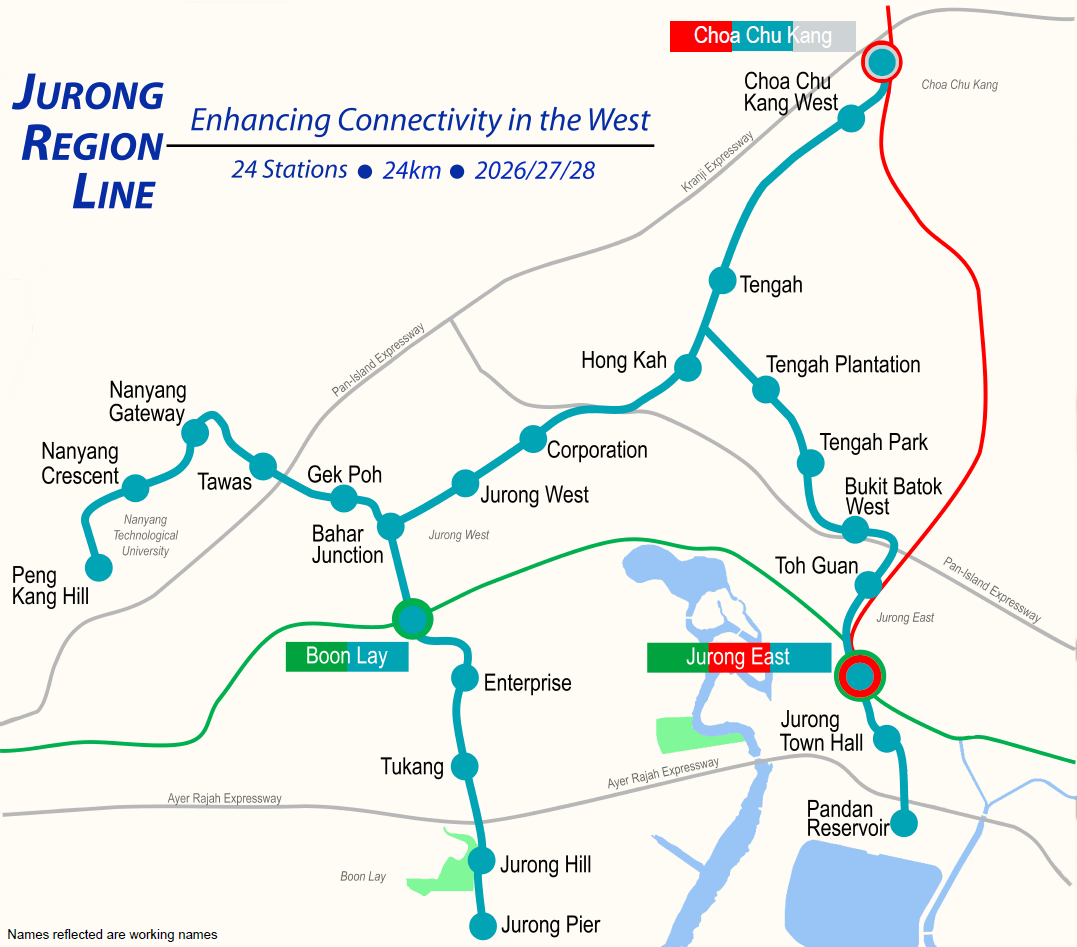
Jurong Region Line initial system map.
Source: Land Transport Authority

This morning the Land Transport Authority (LTA) announced the official stations and route for the Jurong Region Line (JRL). As reflected in our new logo, the route is to be coloured teal. As previously mentioned in our final prediction post, two stations will be deferred and the remainder of stations will be built and opened over 3 separate phases.

Overlay of officially released Jurong Region Line initial system map against geographic map.
Credits: y2koh