 |
| Jurong Region Line initial system map. Source: Land Transport Authority |
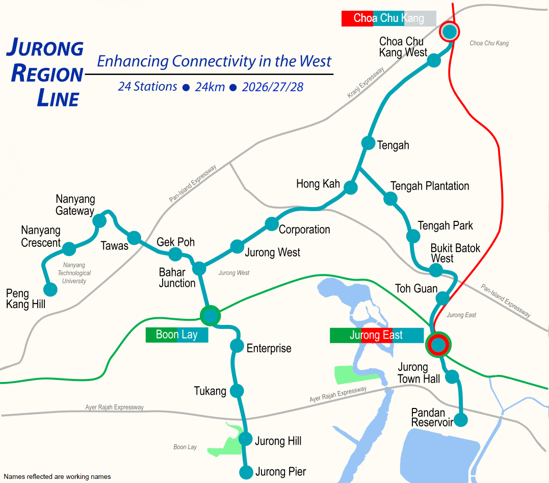
This morning the Land Transport Authority (LTA) announced the official stations and route for the Jurong Region Line (JRL). As reflected in our new logo, the route is to be coloured teal. As previously mentioned in our final prediction post, two stations will be deferred and the remainder of stations will be built and opened over 3 separate phases.
 |
| Overlay of officially released Jurong Region Line initial system map against geographic map. Credits: y2koh |
The rough station location maps are available on the LTA website. These show the outlines of the various stations with the exception of the stations located within Tengah. One noticeable station is Bahar Junction which allows us a look into the unique way in which the JRL may be operated in future.
 |
| Station location map for Bahar Junction station showing the station outline. Source: Land Transport Authority |
In a promotional video show casing the locations served by the JRL, the LTA also provided a different map which was consistent with the display of other lines in the MRT & LRT network. This potentially shows how the Bahar Junction transfer may work.
 |
| Screen grab from LTA promotional video. Source: Land Transport Authority Credit: emi172 |
 |
| Illustration of Bahar Junction station and potential operations at station. Credit: y2koh |
 |
| System map of the initial JRL system showing maintenance facilities as well. Source: Land Transport Authority |
Edit: We've taken out some of the maps from the LTA document for easy reference.
Phase 1 - due 2026
 |
| Station location for Choa Chu Kang - at the current site of the Choa Chu Kang bus interchange, next to North South Line. Source: LTA |
 |
| Station location for Choa Chu Kang West - along Choa Chu Kang Avenue 3 near Sunshine Place neighbourhood mall. Source: LTA |
 |
| Station location for Jurong West - along Jurong West Avenue 2 outside the boy's home & St. Joseph's home. Source: LTA |
 |
| Station location for Bahar Junction - straddling Jurong West Avenue 2, Jurong West St 64 and Jurong West St 75 Source: LTA |
 |
| Station location for Boon Lay interchange - along Jurong West St 64, western end of East West Line station. Source: LTA |
Phase 2 - due 2027
 |
| Station location for Tengah Park - opposite Dulwich College. Source: LTA |
 |
| Station location for Bukit Batok West - along PIE, across from Yuhua estate, near block 172 Bukit Batok West Avenue 8. Source: LTA |
 |
| Station location for Toh Guan - along Jurong East Central, next to North South Line viaduct. Source: LTA |
 |
| Station location for Jurong Town Hall - along Jurong Town Hall Road, opposite International Business Park. Source: LTA |
Phase 3 - due 2028
 |
| Station location for Nanyang Gateway. Source: LTA |
 |
| Station location for Nanyang Crescent. Source: LTA |
 |
| Station location for Peng Kang Hill. Source: LTA |
 |
| Station location for Enterprise - along Jalan Boon Lay. Source: LTA |
 |
| Station location for Tukang - along Jalan Boon Lay. Source: LTA |
 |
| Station location for Jurong Hill - along Jurong Pier Road. Source: LTA |
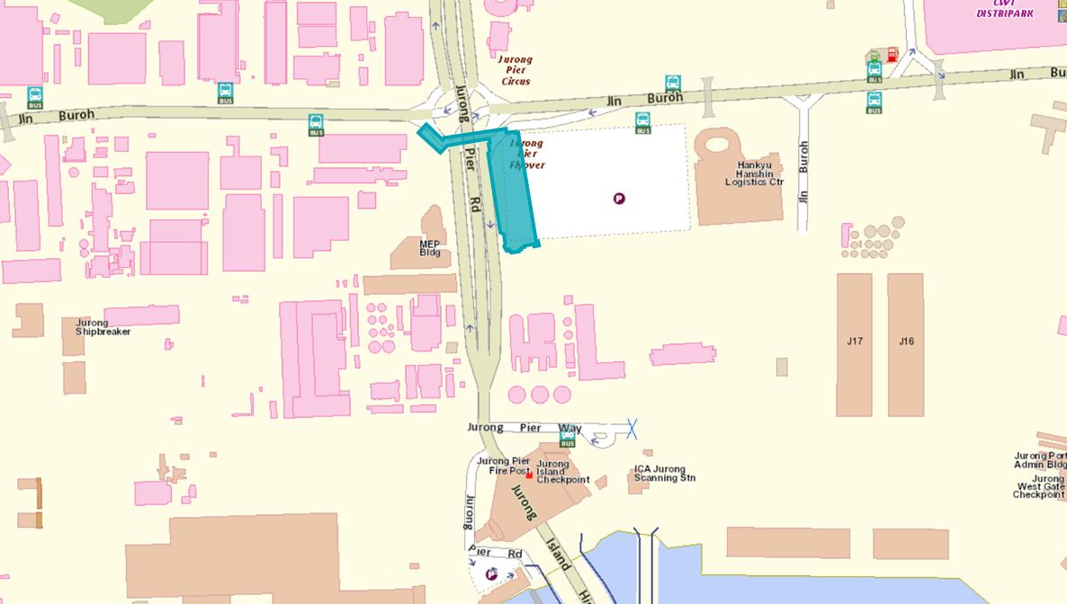 |
| Station location for Jurong Pier - along Jurong Pier Road. Source: LTA |
You’ve mentioned the JRL West Coast Extension in your previous posts, how likely do you think this will happen? Do you have a feeling that they will eventually give the extension a green light but only announce it at a later date to score “value add” points as a service provider?
ReplyDeleteThis is essentially an adaptation of the Docklands Light Railway (DLR) in London, United Kingdom into Singapore, hoping to revitalize the sleepy Jurong region, just as DLR revitalized the Docklands region in UK.
ReplyDeleteThat said, service patterns should be the same as the DLR, with train services running all possible directions.
ReplyDeleteAbout “Bahar Junction”, I’m not expecting such complicated arrangement as stated above. But rather, two tracks for each platform, and infrastructure provided for trains to run from one branch to another, thus the two platforms.
There would be through services from NTU to Boon Lay, Boon Lay to Choa Chu Kang, Choa Chu Kang to NTU, and vice-versa.
I strongly suspect the NTU to Boon Lay through service will use the Jurong West Street 64 platform, whereas the other services that need to turn will use the Jurong West Avenue 4 platform. If so, it really makes sense.
http://uploads.tapatalk-cdn.com/20180510/5d87f74bda415f30accbed432ad725be.jpg
Deletewhere's the cut through from JW1 to JW2. is it through pioneer primary??
ReplyDeleteYou can await an official reply through the Today Voices section: https://www.todayonline.com/voices/any-plans-pioneer-primary-school-move?fbclid=IwAR1iZbTAotHPVS6-OJv8OawSuZ39JLlyHCSVyF7z1YxgBTaG1lGq2HX0BPM
DeleteThe same question has been asked.
Hi,Hong Kah station(JS4)location confirmed,People from jurong west street42 can access to Hong Kah station?
ReplyDeletedistance between JS4 and JS5(cooperation)Station seems quite far,if compare to JS5-JS6,JS6-7.Especially JS5 is only few blocks' distance to JS6,Walk from JS5 to JS6 maybe spent few mintues and may same with train spend time in the two stations.walk from JS5 to JS6 may lesser time than train running time from JS4 to JS5?
some website picture show original JS5 concept/proposed location is behind Jurong Temple,the people along Jurong west st42 seems all easy to access the station.now the JS5 shift to more west side,seems people from all blk no. 4++ around Jurong west street 41 is too far away to access JS5,and seems more closer to JS4 than JS5.But don't know people from JW street 42 can access to JS4(HONG KAH)Station as in bewteen is PIE High way
thks